
OpenForest4D science gateway lets researchers analyze data and use computing resources online without downloads, local hardware, or software setup, enabling accessible, collaborative, and reproducible science.
The OpenForest4D Canopy Height Mapper workflow enables on-demand generation of canopy height maps for any area of interest by combining NASA Global Ecosystem Dynamics Investigation (GEDI) space lidar measurements with Sentinel-2 L2A optical imagery and Sentinel-1 radiometrically terrain-corrected (RTC) SAR data. A machine learning model is trained on GEDI reference measurements and used to predict tree height continuously across the landscape.
Step 0. Login to OpenForest4D using CILogon
CILogon is an identity and access management platform. It provides federated authentication, so users can access cyberinfrastructure platforms like OpenForest4D with their home organization’s credentials (such as university logins, Google, Microsoft, GitHub, and ORCID), avoiding the need to manage separate usernames and passwords for each service.
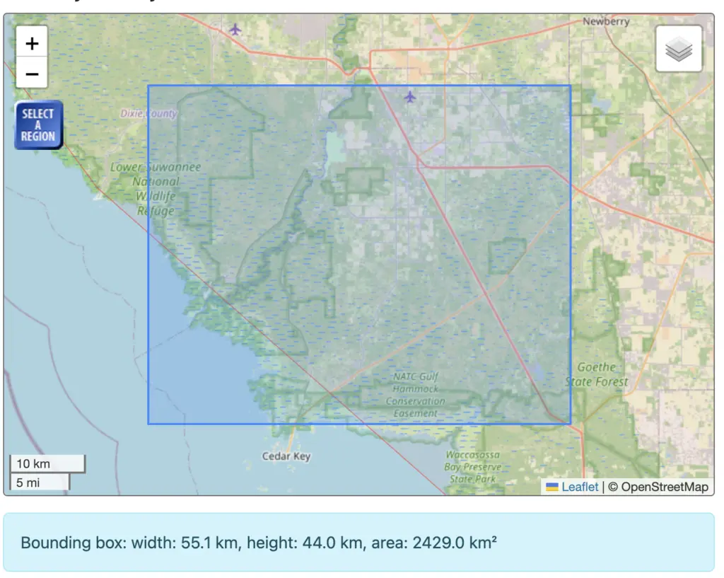
Step 1. Select the spatial area of interest on the map interface
Draw or select the area of interest you want to generate a canopy height map for on the map interface. This defines the spatial extent over which GEDI footprints, Sentinel-1, and Sentinel-2 data will be gathered and the final canopy height map will be produced.
Step 2. Select the output year
Choose the year for which you want to generate a canopy height map. (Default year is 2022)
Step 3. Configure Advanced Settings
Advanced settings control the data sources used to train and build the canopy height model.
Data Sources & Quality Filters
- GEDI lidar measurements date range – Set the start and end date for the reference GEDI space lidar measurements used to train the model.
- Satellite imagery date range – Set the start and end date for the Sentinel-2 L2A optical imagery and Sentinel-1 SAR data used to map canopy height across the full area of interest.
- Sentinel-2 cloud cover limit – Exclude satellite images that are more than X% covered by clouds (10%, 15%, 20% [Default], or 50%). A lower limit produces cleaner imagery but fewer available scenes; a higher limit provides more data but potentially noisier results.
- Include Terrain Elevation (Copernicus GLO-30) – Adding digital elevation model data can improve accuracy in high-relief or mountainous areas.
- Include landcover data (NLCD for the US, ESA WorldCover elsewhere) – Helps the model distinguish forests from other vegetation types.
- Preview input data layers – Generates intermediate visualizations of the source data (GEDI, Sentinel-1, Sentinel-2) used, so you can inspect coverage and quality before the model runs.
Step 4. Choose the Prediction Model
- Machine learning algorithm – Choose between Random Forest Regression and Histogram Gradient Boosting to estimate canopy height from the GEDI, Sentinel-1, and Sentinel-2 predictors.
- Data-splitting method – Choose how reference GEDI data are split for model training and validation:
- Random (Default) – Footprints are shuffled and split into training/validation with no regard to height or location. Simple and fast, but tall-canopy footprints (rarer than short vegetation) can be under-represented, weakening accuracy at the high end.
- By Height Groups – Footprints are binned into height classes (short/medium/tall), then split proportionally within each bin. Ensures tall trees aren’t drowned out by more numerous short-vegetation footprints, improving accuracy across the full height range.
- By Fixed Height Bands – Same stratified approach, but using pre-set, evenly spaced height bands instead of data-driven bins. Gives consistent, reproducible boundaries across runs, useful for comparing results between jobs/areas/years.
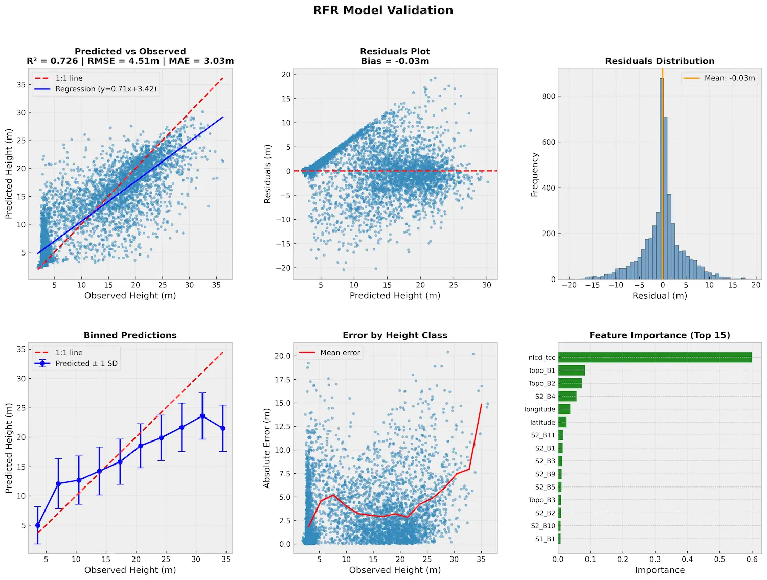
- Generate model explainability report – Optionally produce a report showing which data inputs influenced predictions most, useful for validation and publication.
Step 5. Job Submission
Submit the job once you have chosen the area of interest, output year, advanced settings, and prediction model configuration. The job will execute on cloud-based computing resources, and the resulting canopy height map will be generated automatically. Estimated processing time depends on the size of the selected area and additional options selected. You can view outputs and access records of previous submissions through the My Canopy Height Map Jobs interface of the application.
Products Generated by the Workflow
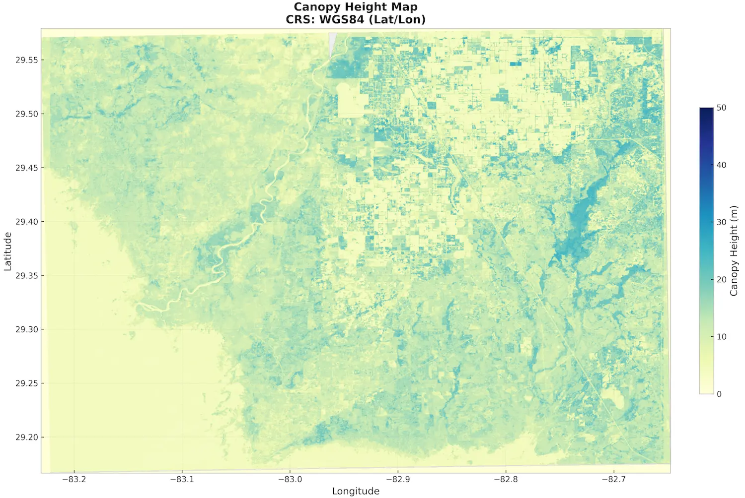
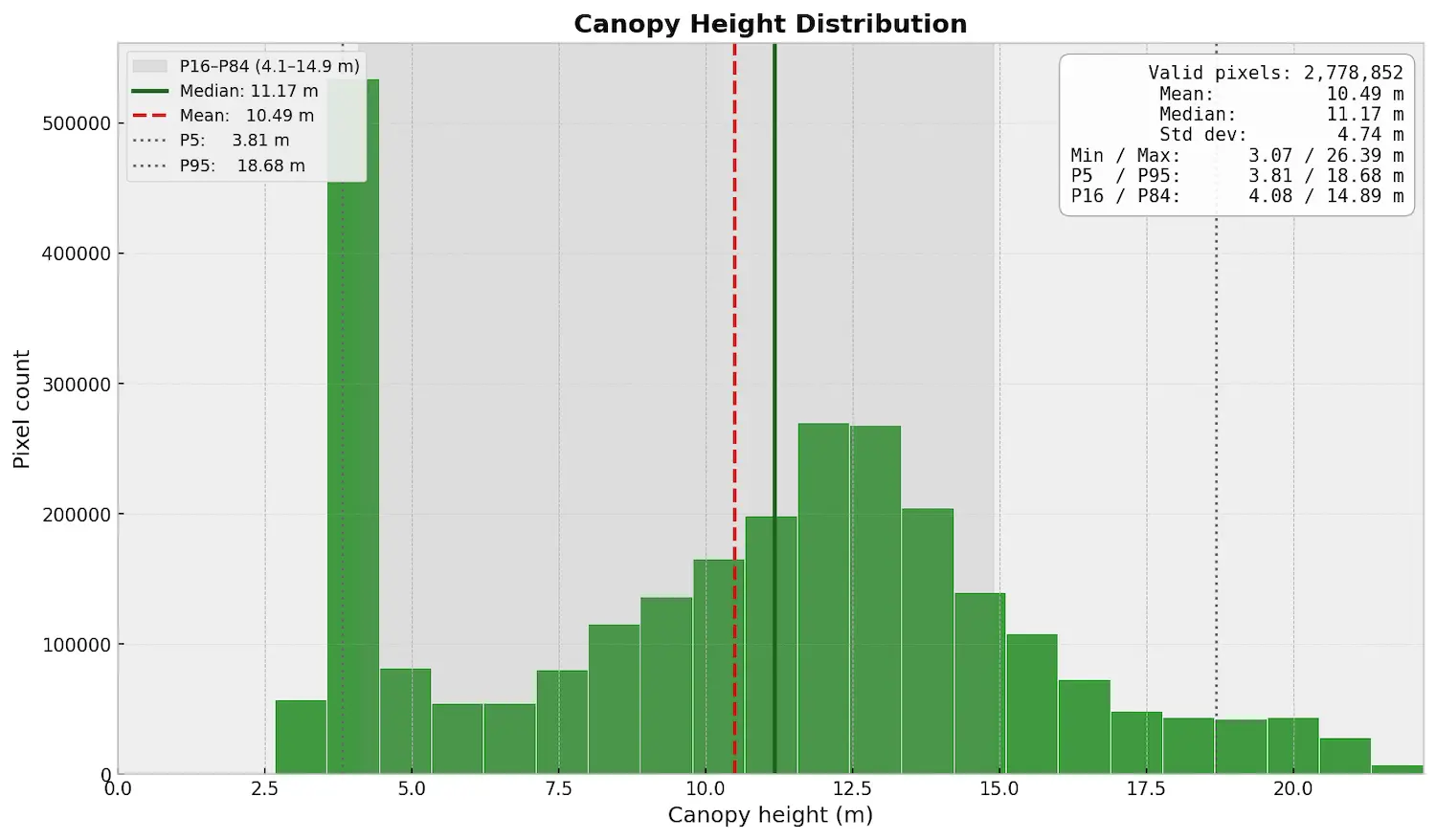
The OpenForest4D Canopy Height Mapper workflow generates:
- Canopy Height Map
- Canopy Height Distribution
- Intermediate input data layer visualizations (GEDI footprints, Sentinel-1, Sentinel-2) – if option is selected.
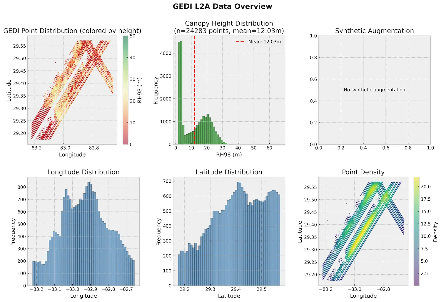
Image: GEDI L2A Data - Model explainability report – if option is selected.
Data Usage and License
GEDI, Sentinel-1, and Sentinel-2 data are made available by NASA and the Copernicus program under their respective open data policies for research, education, and non-commercial or commercial use.
When using canopy height maps generated from the OpenForest4D Canopy Height Mapper workflow in publications and reports, please cite OpenForest4D as well as the underlying datasets.
NSF OpenForest4D. 2026. Canopy Height Map (v1). Produced using the OpenForest4D Canopy Height Mapper (NASA GEDI lidar, Sentinel-1 SAR, Sentinel-2 optical imagery). Accessed {date}. openforest4d.org.
NASA GEDI L2A: Dubayah, Ralph, Michelle Hofton, James Blair, John Armston, Hao Tang, and Scott Luthcke. “GEDI L2A Elevation and Height Metrics Data Global Footprint Level V002.” NASA Land Processes Distributed Active Archive Center, 2021. DOI: 10.5067/GEDI/GEDI02_A.002.
Sentinel-1 RTC: Microsoft. 2026. Microsoft Planetary Computer Sentinel‑1 Radiometrically Terrain Corrected (RTC) collection [Data service]. https://planetarycomputer.microsoft.com/dataset/sentinel-1-rtc European Space Agency (2024).
Sentinel-2 Optical: Copernicus Sentinel-2 (processed by ESA), 2021, MSI Level-2A BOA Reflectance Product. Collection 1. European Space Agency. DOI: 10.5270/S2_-znk9xsj.
Topographic DEM: Copernicus Global Digital Elevation Model. Distributed by OpenTopography. DOI: 10.5069/G9028PQB.
Land Cover:
Dewitz, J., 2024. National Land Cover Database (NLCD) Tree Canopy Cover Products. U.S. Geological Survey. DOI: 10.5066/P9JZ7AO3.
Dewitz, J., 2023. National Land Cover Database (NLCD) 2021 Products: U.S. Geological Survey data release. DOI: 10.5066/P9JZ7AO3.
Zanaga, D. et al. (2022) “ESA WorldCover 10 m 2021 v200”. DOI: 10.5281/zenodo.7254221.
Access the OpenForest4D Canopy Height Mapper workflow*.
* This tool is under active development (Beta). Results should be validated before use in decision-making.
For any questions please email info@openforest4d.org